Friday, June 08, 2007

Coney Island of the Northwest.

Oregon Water Power & Railway Co. began building Oaks Amusement Park in 1904 to stimulate weekend traffic on its interurban electric trolley line running from Portland to Oregon City, & to take advantage of the anticipated millions of visitors in town for the 1905 Lewis & Clark Centennial Exposition. At a cost of $100,000, the "trolley park" opened May 30, 1905, 2 days before the Expo opened at Guild's Lake to the northwest of Portland.1 When the Exposition closed in October, the Oaks acquired its benches, gazebos, & lamp posts2.

image hosted by photobucket
One of the Expo lamps is to the left, the willow-tree-looking thing, there.

After its 1st year of operation, the park was jointly managed by the OWP and the newly incorporated Oaks Amusement Company. The OAC leased the park from the railway for $35,000, w/ the OAC maintaining the grounds & managing concessions. However, the OWP, typical of rail interests in Portland at the time, reaped the lions share of profits, earning 5 cents each way in trolley fares & 10 cents per admission, on top of the $35,000 it was collected from the OAC. The OAC, in contrast, only collected a % of concessions income.

The year construction of the Oaks began, the 2 Portland city-only trolley companies - City & Suburban Railway and Portland Railway - had merged to become Portland Consolidated.3 In 1905, Portland Consolidated was sold to east coast interests & re-renamed Portland Railway Co.
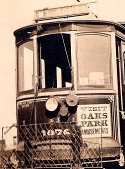
image hosted by photobucket
A Portland trolley w/ advert for Oaks Park.

In 1906 Portland Railway & the OWP merged to become Portland Railway, Light & Power Co. PRL&P assumed ownership of the Oaks on June 29, 1906, & the managing Oaks Amusement Co. was dissolved in the spring of 1907. D.C. Freeman, who had worked in the administration of Lewis & Clark Exposition, was made manager of the park.

image hosted by photobucket

Local entertainment mogul John F. Cordray leased the park in 1909, giving the Oaks more leverage w/ the local papers & City Hall. In the 1920s, laws were passed prohibiting electric companies like the PRL&P from owning amusement parks, making the "trolley park" phenomena an anachronism, & Cordray purchased the Oaks outright.4

image hosted by photobucket
A trolley is visible in the distance of this view.

Although Oaks Park proudly marches on to this day, if I were to make some changes, I'd like to see (a) one decent roller coaster, & (b) a real slammin' video arcade. I mean, Avalon on Belmont is great & all, but the selection can be a bit stale5, & I'm not always in the mood to deal w/ the Bourbon Street-esque flavor surrouding Ground Kontrol on a Friday or Saturday night.6 While they're at it, can they rebuild the Oaks Tavern?7

-d.d.


1 Sellwood Park had been a potential location for the Expo. So was Ross Island (imagine how different the city might be if that had happened) and 'Hawthorne Park,' a large open space between Hawthorne and Division and 9th & 12th.
2 Purportedly one of the Expo lamps still works and is on display in The Oaks Museum. This past summer I wandered the entire Oaks property & I believe that this building is (or was) the "museum," but it was neither open nor appeared to have been for some time. Peeking thru the windows, I spied old pictures on the walls w/ description cards under them, but that was it.
3Abridged History of Portland's Trolley Years.
1891: The City & Suburban Railway Co. acquires a fistful of smaller trolley companies to become largest streetcar company west of the Mississippi
1892: The Portland Consolidated Street Railway Co. emerges as the counterpart to the City&Suburban.
1893: The East Side Railway Co. completes 1st electric interurban line in the U.S. between Portland & Oregon City.
1896: Portland Consolidated goes bankrupt & is purchased by Portland Railway Company.
1901: East Side Railway Co. sold in foreclosure & eventually emerges as Oregon Water Power & Railway Co. by 1902.
1904: Portland Railway and City & Suburban merge, forming Portland Consolidated Railway.
1905: Portland Consolidated Ry. sold to east coast interests for $6million & name changed to the (second) Portland Railway Co.
1906: Portland Railway consolidated w/ Oregon Water Power & Railway to become Portland Railway, Light and Power Company. PRL&P presided over a system of 28 streetcar & interurban lines, zenith-ing in the years just prior to World War I.
1924 PRL&P changes name to Portland Electric Power Company (PEPCO), but lines remained essentially the same. Although PEPCO operated 3rd largest narrow gauge streetcar system in the US, growth slowed during the 1920s as cutbacks in service & labor, such as remodeling equipment to facilitate one-man car operation, became the norm.

4 For more info on Oak's Park, see Sara Paulson's The Oaks in the Progressive Era.
5 By "stale," of course, I actually mean "too new." As in, everything's a racer or a shooter. & they took away Virtual On. What happened to the side-scroller shooter? Metal Slug, anyone?
6 Or the pre-emptive heavy police presence.
7 see The Oaks Tavern (1905-1920s), June 16, 2006.

Thursday, May 17, 2007

Fallout Protection
What to Know & Do About Nuclear Attack.

Fallout001 Fallout002

Fallout003 Fallout004

Fallout005 Fallout006

Fallout007 Fallout008

These are all from a 1961 Dept. of Def. publication.1 That orangey color is really... eye-catching. My favorite's that last one: Mom & dad & child in thier little fallout shelter, dad cranking the hand-driven ventilator, mom reading the ONE BOOK in the shelter. What's 2 weeks when you have family?

-d.d.

1 W/ an intro by Robert McNamara!!

Monday, April 30, 2007

Peace Special.

image hosted by Flickr.

My maternal grand-aunt was a Red Cross nurse stationed in Portsmouth, England, during the first world war. This newspaper, not surprisingly, was in the back of her scrapbook. Sorry the paper won't fit on a modernday scanner. I like how the paper is formatted to be folded in half vertically, with a solid 2 inches of blank paper in the middle.

-d.d.

Friday, April 20, 2007

Down in Jungle Town.

So, back in the late '40s, there was a record label outta Portland called Castle. Castle was the (presumably) exclusive label for the Castle Jazz Band.

hosted by flickr

The Castle Jazz Band used to play out of the Castle Restaurant down in south Milwaukie, above the Clackamas river, which was recently demolished, I think.1

Found the above record label-piece in a rubbish bin, only loosely connected to the shattered remains of a 48.

-d.d.

1 Or so reports the always entertaining Schlockstar.

Wednesday, April 18, 2007

Color - Color Blazing, and Color Murky.

It turns out my mother's aunt, who went to college1 in, like, 1907 or something, when that was kinda not the thing ladies did, AND THEN never married, was a bit of the homebrew historian.2 Her typewriter-keyed manuscript weighs in at a hefty 250+ pages, including some loose newspaper & magazine clippings from the early-to-mid '60s.

On the back of a magazine article is this gem...


Click to enlarge

The "currently fashionable two-piece swimsuit?" Apparently this mag was too frou-frou to just call it a bikini.

Still, love that swank '60s ad art.

-d.d.

1 Psychology.
2 And, evidently, a bit of the fanciful illustrator.

Wednesday, February 07, 2007

Eastmoreland / Errol Heights Line

In 1910 the Ladd Estate Co. laid tracks east of existing PRL&P tracks on Milwaukie up Bybee to the site of the under-construction Reed College.1 Two years later the tracks to the campus were removed, & new tracks laid heading south of Bybee at S.E. 32nd, terminating at Rex Avenue. The LEC leased trolleys from PRL&P to service the new real estate development, called Eastmoreland. That same year the line was donated to PRL&P by the LEC.

In 1913 track was laid by another real estate developer, the Fred A. Jacobs Co., off the 32nd Ave. Eastmoreland tracks heading east on Knapp.

image hosted by photobucket.
Red line is the original Eastmoreland line, green the Errol Heights extension.


Maintained by the Errol Heights Railway Co., w/ a car & operator supplied by PRL&P at 91.4 cents per car-hour, the car ran 10 & a half hours a day. Riding the Errol Heights line was free, FA Jacobs/EHR assuming all costs. 150 or so people rode the line each way daily, but despite this ridership, offers by EHR to sell the line to PRL&P were rejected, PRL&P citing a policy of not operating lines 5 miles from the city's center.2 Its unclear how & why, but the line was merged into the Eastmoreland route in the 1920s anyways (I would guess EHR simply surrendered the line).

The merged Eastlmoreland/Errol Heights line trundled on until 1926, when most of the line was converted to gas bus. The Errol Heights section, at least, appears to have been completely abandoned in 1929.

While there are no photos of trolleys on the Errol Heights line, the only car known to have operated on it was the 1500. Built in 1892 by the Patton Motor Car Co. as an experimental single truck (one set of four wheels) gas-elec. trolley, it first made runs on the Metropolitan Railway's3 standard guage line, which ran 6 miles from downtown at 2nd & Glisan south to Riverview Cemetary. Use of the 1500 on this line was considered a failure, but the car was remodeled in 1903 into a double-truck all-elec. car.

image hosted by photobucket.
No. 1500 as a mail car.

From thereon, it moonlighted variously as an interurban car, parlor car, funeral car, mail car, &, finally, a passenger car on the Errol Heights line. Retired in 1921, it was the only car w/ a center entrance to have seen significant use.4

image hosted by photobucket.
No. 1500 as a funeral car.

Trolley funeral cars were available in many large American cities in the early 20th Century. W/ unpaved roads & horse-drawn hearses, trolley funeral cars offered a more civilized journey for the deceased. Trolleys were chartered to transport the funeral party to & from a cemetary along an existing trolley line. They usually included a small door on the side of the car at floor level for loading & unloading the casket. Usually, upon arrival at the cemetery, the casket would be transferred to a hand carrier & wheeled to graveside.

-d.d.

1 Boxcars were also rented by LEC from PRL&P to assist, presumably, in the construction of Reed College's oldest buildings.
2 Labbe, John. Fares, Please!: Those Portland Trolley Years. Caxton Printers, Ltd. Caldwell, Idaho. 1980. p. 158-159.
3 Incorporated 1889, sold to the Multnomah Street Railway Co. in 1892.
4 Thompson, Richard. Portland's Streetcars. Arcadia Publishing. 2006. p.98

Friday, January 26, 2007

Alberta Line.

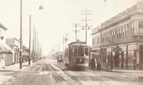
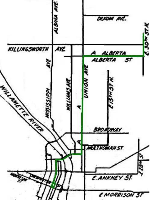
Portland Railway Co. initated the Alberta Line (1903-1949), running from a downtown loop of 2nd-Morrison-3rd-Washington out to its terminus at N.E. Alberta and 25th.

William Hayes collection
W. Hayes collection

Isn't that building on the right still standing? It looks really familiar but I can't place it.

By 1909, the line had been extended in spurts to N.E. 30th at Ainsworth.


Converted to bus in 1949.

-d.d.

Monday, January 08, 2007

A Few More Demolished Buildings of PDX.

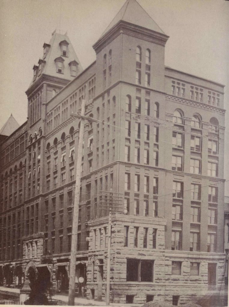
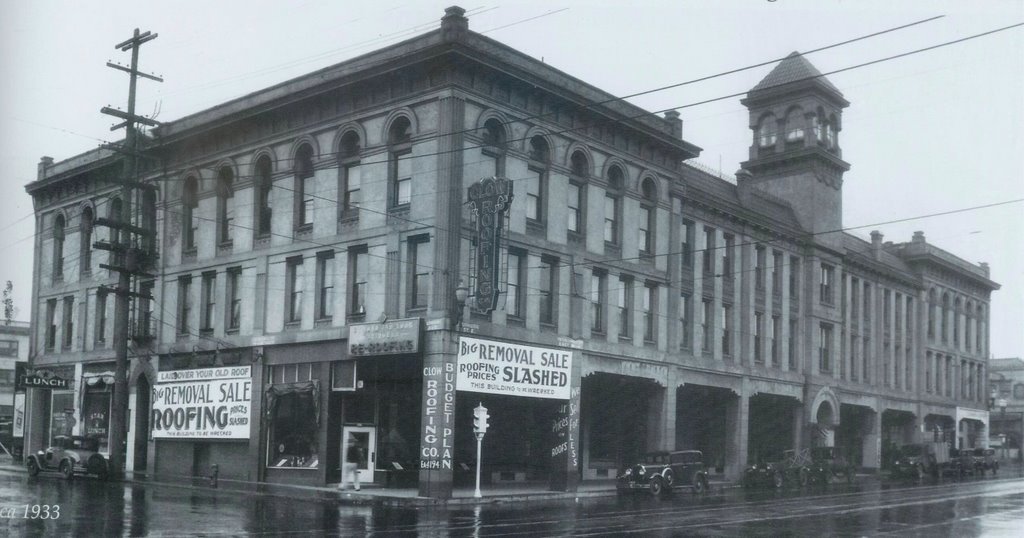
I have several never-posted PDX's Historic Trolley Lines map entries I'm trying to get around to actually posting. But before I do that I figured I would add the sites of the Marquam Grand & the Burkhard Building to the Demolished Buildings of PDX map.

image hosted by Blogger
The Marquam Grand

image hosted by blogger
The Burkhard Building

Credit where credit's due: Dan Haneckow at Cafe Unknown did the research & wrote far-more-in-depth-posts-than-I-ever-could on both these buildings.

-d.d.

Thursday, January 04, 2007

Mapping Historic Portland.

image hosted by blogger


A week & a half ago I received notification that a Tinzeroes Platial map had received a Platial "2006 Map Award." First of all, I confess a deep-seeded self-loathing when it comes to my neglected Platial geography projects these days: the viscera of Portland history I've been delving into of late is less map-able than trolleys crossing intersections or buildings that used to be at such-&-such streets. Secondly, at least initially, if I were to pick one of my 4 platial maps as a "favorite," I would probably pick Demolished Buildings of PDX over actual 2006 "Best Local History Map" winner Historical Portland Trolley Lines.

But then I took a gander at the trolley map, & although it is rather skimpy in terms of factual information, & although its largely a mapping of research & photos compiled by other people, I suppose it is, truthfully, a fairly interesting juxapositioning of historical data using a rather unique infobahn tool. To borrow from a friend's synopsis, the Trolley Map presents handy historical "capsules" for injestion: small in content but easily digestible.

I guess now is as good of a time as any to mention that some of the glitter of Portland's trolley heyday has tarnished a bit for me. At its apex, Portland's (privately owned) trolley network was deeply rooted in conflicts of interest scandalous by today's standards: city contracts handed to individuals who held significant ownership stakes in the trolley network, who in turn used same city-contracted tracks to move materials for other city public works projects - think if Tri-Met were a private corporation, & then one of its major shareholders received the contract to build the tram, & then used Tri-Met rails to move tram materials to the construction site at no cost to himself.

With the ol' Trolley map, I was certainly smitten w/ the rather romanticized concept of these wonders of public transportation inadvertently laying a foundation for Portland's current uniqueness. The initial conclusion I drew from this observation was that urban planning was as much dumb luck as anything else, if not exclusively the same. I suppose that conclusion is unchanged, but iced w/ a considerably larger serving of pessimism: monied interests lining thier pockets w/ tax-payer dollars, over & over, throughout history.

But hey, enough of this tragedy of history stuff, right? Lets looky at some real maps! Like this electoral ward map of Portland, circa 1905.

image hosted by photobucket.

Things of interesting note: the map shows the then city limits. Although there are 10 wards, it really sticks out at me that 6 of them are on the remarkably smaller-in-area west side, which underlines the way in which the city's demographics were drastically different in terms of population density 100 years ago: most people lived "downtown," and the eastside, while growing, was less dense & less populous.

Next map.

This 1 shows the ethnic layout of Portland circa 1913. If you had any doubts as to Portland's white-ness, I suppose this can lay those doubts to rest. Modern-day anxiety over Portland's snowy reputation aside, its always somewhat bizarre to think that a century ago the presence of Swedish, Norwegian, & German immigrants were considered noteworthy. Chinatown is clearly defined, although the area apparently immediately south of Ladd's Addition once being predominately black, or the German- & Russian-Jewish enclaves in the Lair Hill vicinity caught me off guard. The Italian presence in & around the Brooklyn Yards I had heard about.
image hosted by photobucket.
Next up is a map of "high-rent" & "working-class" neighborhoods in Portland. Anyone who has spent a significant amount of time touring Portland & taking the time to note the size & style of the older homes should not be surprised by the layout presented by this map. Still, Goose Hollow: working class? That does not jive w/ my perceptions.

image hosted by photobucket.

All 3 maps are from MacColl's Shaping of a City.1

-d.d.

1 MacColl, E. Kimbark. The Shaping of a City: Business and Politics in Portland Oregon 1885 to 1915. The Georgian Press Company, Portland, Oregon. 1976. p. 346, 460, 463.

Tuesday, December 12, 2006

(Lesser) Demolished Buildings of PDX.

There used to be an old garage or machine shop at the corner of SE Division & (lower) Grand Avenue. If you were driving by on the viaduct, where Grand & MLK become McLoughlin, you would only see an old rooftop, maybe. I think it was last winter but I was riding home from work and noticed the old building had chainlink fence around it, a minor construction tractor of some sort & a large dumpster standing by. This old building was getting torn down.

When I got home I looked the address up on Portland Maps &, yeah, the shop was old, like 1925 or so. I wanted to take photos but it was already dark (winter = dark by 5:30). I tried to remind myself to just bring my camera to work so I could snap a photo on the way home the next day or two but I kept forgetting. The demolition continued. The building was City property & was being cleared to make way for the eventual re-building of the Grand/MLK/McLoughlin viaduct in 2007. I remember it had a lot of brickwork & thick wooden beams. And let's be honest, it probably rested upon contaminated soil. The front doors of the building faced east, on to the original, pre-viaduct Grand Avenue - the one where the old Bridge Transfer Line trolley tracks still lie. Funny there, the viaduct put the building out of business, & the new viaduct put it out of its misery.

Waxing my way along here, my point is that buildings get demolished everyday, usually to little hooplah or even notice by anyone 'cept bizarros like me. On one of those last weekends of nice weather in September, I walked around parts of central eastside, taking snapshots. Included was this quirky little building at 2008 S.E. 11th.

image hosted by Flickr

Yeah, you know the one? Right? The window had a sign painted on about the "Past & Present" shop or some such, & the door said "Psychic" on it. A fortune teller!

Part of my project that day had been to cross-reference the buildings I took pics of w/ Portland Maps - see when they were built, try to get a feel for the lay of the town back when. I swear this little shop-front was built in 1910 or close to it.

Why am swearing it was built in 1910? Because Portland Maps doesn't include the "original built" info for 2008 SE 11th anymore, because it be not there anymore...

image hosted by flickr

Further demolition revealed that the building had a full basement, which, honestly, surprised me a bit. And to be honest, it probably had terminal mold problems.

2008 SE 11th Avenue
c.1910-2006.
We Hardly Knew Ye.

-d.d.