Wednesday, February 07, 2007

Eastmoreland / Errol Heights Line

In 1910 the Ladd Estate Co. laid tracks east of existing PRL&P tracks on Milwaukie up Bybee to the site of the under-construction Reed College.1 Two years later the tracks to the campus were removed, & new tracks laid heading south of Bybee at S.E. 32nd, terminating at Rex Avenue. The LEC leased trolleys from PRL&P to service the new real estate development, called Eastmoreland. That same year the line was donated to PRL&P by the LEC.

In 1913 track was laid by another real estate developer, the Fred A. Jacobs Co., off the 32nd Ave. Eastmoreland tracks heading east on Knapp.

image hosted by photobucket.
Red line is the original Eastmoreland line, green the Errol Heights extension.


Maintained by the Errol Heights Railway Co., w/ a car & operator supplied by PRL&P at 91.4 cents per car-hour, the car ran 10 & a half hours a day. Riding the Errol Heights line was free, FA Jacobs/EHR assuming all costs. 150 or so people rode the line each way daily, but despite this ridership, offers by EHR to sell the line to PRL&P were rejected, PRL&P citing a policy of not operating lines 5 miles from the city's center.2 Its unclear how & why, but the line was merged into the Eastmoreland route in the 1920s anyways (I would guess EHR simply surrendered the line).

The merged Eastlmoreland/Errol Heights line trundled on until 1926, when most of the line was converted to gas bus. The Errol Heights section, at least, appears to have been completely abandoned in 1929.

While there are no photos of trolleys on the Errol Heights line, the only car known to have operated on it was the 1500. Built in 1892 by the Patton Motor Car Co. as an experimental single truck (one set of four wheels) gas-elec. trolley, it first made runs on the Metropolitan Railway's3 standard guage line, which ran 6 miles from downtown at 2nd & Glisan south to Riverview Cemetary. Use of the 1500 on this line was considered a failure, but the car was remodeled in 1903 into a double-truck all-elec. car.

image hosted by photobucket.
No. 1500 as a mail car.

From thereon, it moonlighted variously as an interurban car, parlor car, funeral car, mail car, &, finally, a passenger car on the Errol Heights line. Retired in 1921, it was the only car w/ a center entrance to have seen significant use.4

image hosted by photobucket.
No. 1500 as a funeral car.

Trolley funeral cars were available in many large American cities in the early 20th Century. W/ unpaved roads & horse-drawn hearses, trolley funeral cars offered a more civilized journey for the deceased. Trolleys were chartered to transport the funeral party to & from a cemetary along an existing trolley line. They usually included a small door on the side of the car at floor level for loading & unloading the casket. Usually, upon arrival at the cemetery, the casket would be transferred to a hand carrier & wheeled to graveside.

-d.d.

1 Boxcars were also rented by LEC from PRL&P to assist, presumably, in the construction of Reed College's oldest buildings.
2 Labbe, John. Fares, Please!: Those Portland Trolley Years. Caxton Printers, Ltd. Caldwell, Idaho. 1980. p. 158-159.
3 Incorporated 1889, sold to the Multnomah Street Railway Co. in 1892.
4 Thompson, Richard. Portland's Streetcars. Arcadia Publishing. 2006. p.98

Friday, January 26, 2007

Alberta Line.

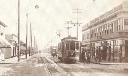
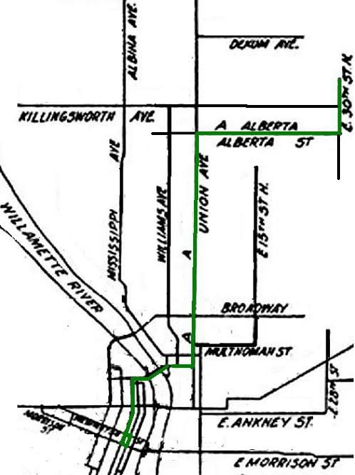
Portland Railway Co. initated the Alberta Line (1903-1949), running from a downtown loop of 2nd-Morrison-3rd-Washington out to its terminus at N.E. Alberta and 25th.

William Hayes collection
W. Hayes collection

Isn't that building on the right still standing? It looks really familiar but I can't place it.

By 1909, the line had been extended in spurts to N.E. 30th at Ainsworth.


Converted to bus in 1949.

-d.d.

Monday, January 08, 2007

A Few More Demolished Buildings of PDX.

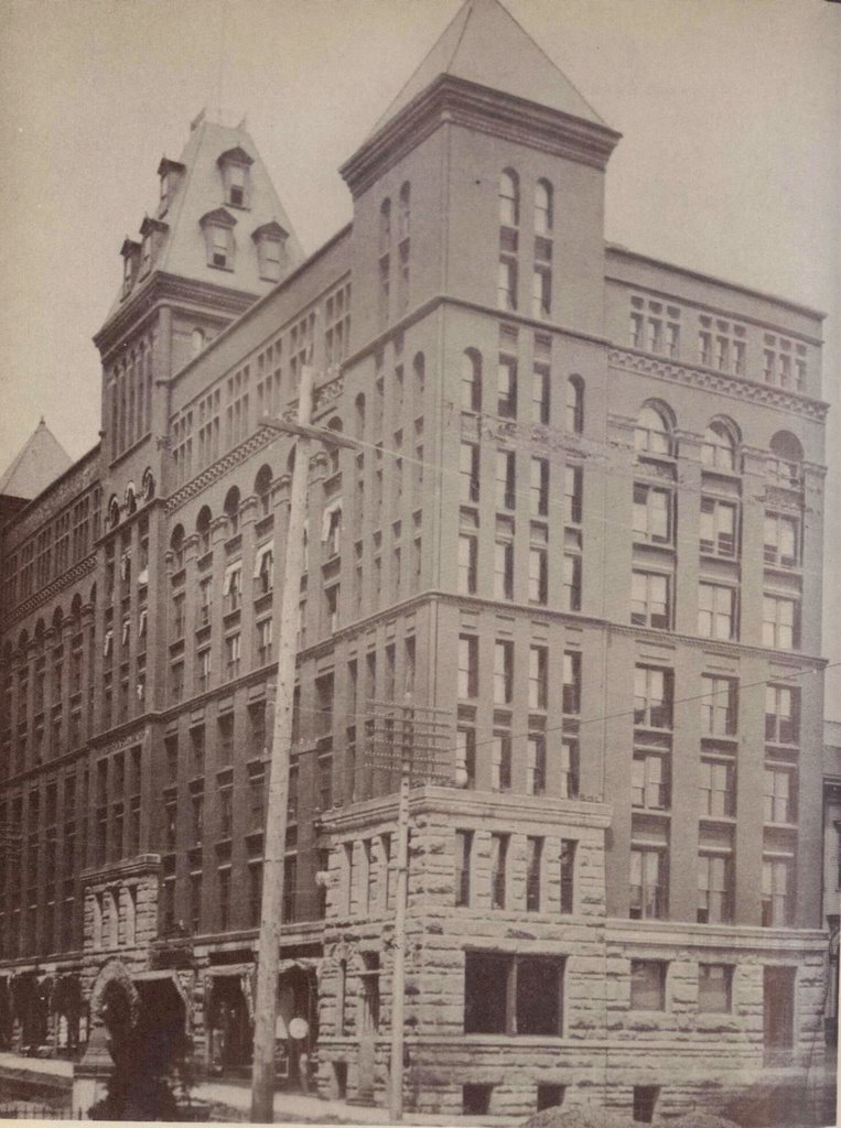
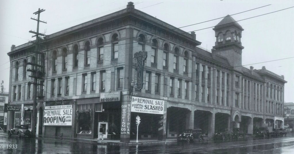
I have several never-posted PDX's Historic Trolley Lines map entries I'm trying to get around to actually posting. But before I do that I figured I would add the sites of the Marquam Grand & the Burkhard Building to the Demolished Buildings of PDX map.

image hosted by Blogger
The Marquam Grand

image hosted by blogger
The Burkhard Building

Credit where credit's due: Dan Haneckow at Cafe Unknown did the research & wrote far-more-in-depth-posts-than-I-ever-could on both these buildings.

-d.d.

Thursday, January 04, 2007

Mapping Historic Portland.

image hosted by blogger


A week & a half ago I received notification that a Tinzeroes Platial map had received a Platial "2006 Map Award." First of all, I confess a deep-seeded self-loathing when it comes to my neglected Platial geography projects these days: the viscera of Portland history I've been delving into of late is less map-able than trolleys crossing intersections or buildings that used to be at such-&-such streets. Secondly, at least initially, if I were to pick one of my 4 platial maps as a "favorite," I would probably pick Demolished Buildings of PDX over actual 2006 "Best Local History Map" winner Historical Portland Trolley Lines.

But then I took a gander at the trolley map, & although it is rather skimpy in terms of factual information, & although its largely a mapping of research & photos compiled by other people, I suppose it is, truthfully, a fairly interesting juxapositioning of historical data using a rather unique infobahn tool. To borrow from a friend's synopsis, the Trolley Map presents handy historical "capsules" for injestion: small in content but easily digestible.

I guess now is as good of a time as any to mention that some of the glitter of Portland's trolley heyday has tarnished a bit for me. At its apex, Portland's (privately owned) trolley network was deeply rooted in conflicts of interest scandalous by today's standards: city contracts handed to individuals who held significant ownership stakes in the trolley network, who in turn used same city-contracted tracks to move materials for other city public works projects - think if Tri-Met were a private corporation, & then one of its major shareholders received the contract to build the tram, & then used Tri-Met rails to move tram materials to the construction site at no cost to himself.

With the ol' Trolley map, I was certainly smitten w/ the rather romanticized concept of these wonders of public transportation inadvertently laying a foundation for Portland's current uniqueness. The initial conclusion I drew from this observation was that urban planning was as much dumb luck as anything else, if not exclusively the same. I suppose that conclusion is unchanged, but iced w/ a considerably larger serving of pessimism: monied interests lining thier pockets w/ tax-payer dollars, over & over, throughout history.

But hey, enough of this tragedy of history stuff, right? Lets looky at some real maps! Like this electoral ward map of Portland, circa 1905.

image hosted by photobucket.

Things of interesting note: the map shows the then city limits. Although there are 10 wards, it really sticks out at me that 6 of them are on the remarkably smaller-in-area west side, which underlines the way in which the city's demographics were drastically different in terms of population density 100 years ago: most people lived "downtown," and the eastside, while growing, was less dense & less populous.

Next map.

This 1 shows the ethnic layout of Portland circa 1913. If you had any doubts as to Portland's white-ness, I suppose this can lay those doubts to rest. Modern-day anxiety over Portland's snowy reputation aside, its always somewhat bizarre to think that a century ago the presence of Swedish, Norwegian, & German immigrants were considered noteworthy. Chinatown is clearly defined, although the area apparently immediately south of Ladd's Addition once being predominately black, or the German- & Russian-Jewish enclaves in the Lair Hill vicinity caught me off guard. The Italian presence in & around the Brooklyn Yards I had heard about.
image hosted by photobucket.
Next up is a map of "high-rent" & "working-class" neighborhoods in Portland. Anyone who has spent a significant amount of time touring Portland & taking the time to note the size & style of the older homes should not be surprised by the layout presented by this map. Still, Goose Hollow: working class? That does not jive w/ my perceptions.

image hosted by photobucket.

All 3 maps are from MacColl's Shaping of a City.1

-d.d.

1 MacColl, E. Kimbark. The Shaping of a City: Business and Politics in Portland Oregon 1885 to 1915. The Georgian Press Company, Portland, Oregon. 1976. p. 346, 460, 463.

Tuesday, December 12, 2006

(Lesser) Demolished Buildings of PDX.

There used to be an old garage or machine shop at the corner of SE Division & (lower) Grand Avenue. If you were driving by on the viaduct, where Grand & MLK become McLoughlin, you would only see an old rooftop, maybe. I think it was last winter but I was riding home from work and noticed the old building had chainlink fence around it, a minor construction tractor of some sort & a large dumpster standing by. This old building was getting torn down.

When I got home I looked the address up on Portland Maps &, yeah, the shop was old, like 1925 or so. I wanted to take photos but it was already dark (winter = dark by 5:30). I tried to remind myself to just bring my camera to work so I could snap a photo on the way home the next day or two but I kept forgetting. The demolition continued. The building was City property & was being cleared to make way for the eventual re-building of the Grand/MLK/McLoughlin viaduct in 2007. I remember it had a lot of brickwork & thick wooden beams. And let's be honest, it probably rested upon contaminated soil. The front doors of the building faced east, on to the original, pre-viaduct Grand Avenue - the one where the old Bridge Transfer Line trolley tracks still lie. Funny there, the viaduct put the building out of business, & the new viaduct put it out of its misery.

Waxing my way along here, my point is that buildings get demolished everyday, usually to little hooplah or even notice by anyone 'cept bizarros like me. On one of those last weekends of nice weather in September, I walked around parts of central eastside, taking snapshots. Included was this quirky little building at 2008 S.E. 11th.

image hosted by Flickr

Yeah, you know the one? Right? The window had a sign painted on about the "Past & Present" shop or some such, & the door said "Psychic" on it. A fortune teller!

Part of my project that day had been to cross-reference the buildings I took pics of w/ Portland Maps - see when they were built, try to get a feel for the lay of the town back when. I swear this little shop-front was built in 1910 or close to it.

Why am swearing it was built in 1910? Because Portland Maps doesn't include the "original built" info for 2008 SE 11th anymore, because it be not there anymore...

image hosted by flickr

Further demolition revealed that the building had a full basement, which, honestly, surprised me a bit. And to be honest, it probably had terminal mold problems.

2008 SE 11th Avenue
c.1910-2006.
We Hardly Knew Ye.

-d.d.

Tuesday, November 21, 2006

Venetian Grand Canal of Portland.

The 1905 Lewis & Clark Centennial Exposition (& American Pacific Exposition & Oriental Fair - the full name of the event), consistent w/ previous World's Fairs1, was comprised of two axis: exhibits & entertainments. The exhibits resided in large, ornate buildings in a Spanish style, & were hosted by various geo-political entities: Japan, Italy, California, Chehalem county. The "entertainments," by contrast, had a more amusement park feel, & were clustered together on a street, built up on pylons over Guilds Lake, called "the Trail."

All in all, there were over 30 amusements along the Trail. They ranged from "replicas" of exotic locales (Cairo, Siberia, Alaska, Japan) to the carnival (haunted castles, temples of mirth) to the sensational & bizarre (intelligent horses).

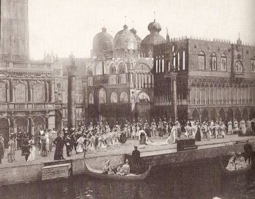
My favorite, however, was the Carnival of Venice, produced by the world-famous Bolossy Kiralfy. Kiralfy (and his brother Imre's) expertise was grandoise, spectacular productions, including Jules Vernes' A Trip to the Moon.2 Carnival of Venice was no exception, featuring a 300 member cast performing dance, song & skit on a 400-foot set complete w/ gondalas.

image hosted by photobucket.
The set & cast of Carnival of Venice.

If the set & size of the cast seems extravagent, keep in mind said cast included European ballerinas & members of the Metropolitan Opera Company.3 This production was not cheap. And, unfortunately, the Carnival of Venice, like the vast majority of the entertainments of the Trail, operated at a loss.4 The Carnival would have closed early if not for the charity of the Exposition's management company, which buoyed the production financially 'til the Expo's close in October.5

-d.d.

1 Although the 1905 Expo was not officially sanctioned such as to designate it a "World's Fair," it remained only event of that nature which occurred that year, making it the 1905 World's Fair by default if nothing else. Or at least that's the story I'm sticking to.
2 In his own words regarding Trip to the Moon, "It dealt with a young prince of the Kingdom of Nowhere. Tired of life on earth, he builds a cannon a mile long so that he can be shot up to the moon. Once there he falls in love with a lunar princess. The story was too farcical, but allowed for unusual ballets. The construction of the massive cannon was a dance production scene set in a foundry."
3 "Complete with serenading gondoliers and scheming lovers who drifted between audience and stage, Bolossy Kiralfy's 400-foot-long set recalled Venice's Grand Canal during the height of the legendary city's gay carnival season. The carnival's 300 members, including a large contingent of European ballerinas and a chorus drawn from the Metropolitan Opera Company, entertained fairgoers with dances, songs and skits." Abbott, Carl. The Great Extravaganza; Portland & the Lewis & Clark Exposition. Oregon Historical Society. Portland, Oregon. 1981. p. 48.
4 The exceptions being, possibly, the Siberia et al. stuff.
5 "Though vistors had to pass along The Trail to reach the federal buildings, they apparently saved thier money for 10cent vaudeville shows downtown or unmentionable pleasures in Chinatown. The elaborate Carnival of Venice, for one example, would have closed its doors and beached its gondolas without the quiet assistance from the Exposition management." Abbott, p. 64

Sunday, November 05, 2006

Please Help the Blind.

In the Old Town Ambulations post, I made reference to an illustration a 1889 issue of West Shore which described Portland's north end as follows:
A ten-year-old boy lies sprawled on a curb dead drunk. From an open window a prostitute solicits. Three Chinese pose proudly in thier gambling establishment. Through all of this a Portland policement passes, tapping his way with a white cane, and bearing a sign which reads, "Please help the blind."7
With a twinkle in my eye, I found a book containing said illustration.2

image hosted by photobucket. you may click to enlarge.


The man standing at the very right edge is being solicited by aforementioned prostitute at an open window (you can glimpse the edge of the window). The little girl being run down in the street by a carriage is pretty horrible. Can't quite figure out what's supposed to be going on in & front of the building on the left. Whatever it is, the "___ Bank" is clearly up to no good.

-d.d.

1 Portland; A Historical Sketch and Guide. O'Donnell, Terence, and Vaughn, Thomas. Oregon Historical Society, Portland, Oregon. 1976. p. 35
2 The Shaping of a City; Business and Politics in Portland, Oregon 1885-1915. MacColl, E. Kimbark. Georgian Press Company, Portland, Oregon. 1976. p. 193.

Wednesday, October 25, 2006

The Willamette Meteor.

In autumn of 1902, nearabouts modernday West Linn, William Dale was visited by his nieghbor & fellow miner, a Welshman by the name Ellis Hughs. The day before he had come across a strange rock, partially buried, about 3/4ths of a mile from his property, Hughs confideded. The pair went to have a gander at it & the curious cavities burrowed into it, some voluminous enough to contain a child. At some point Dale hit it w/ a rock, & gave it out a ringing sound. At this sound, both knew it to be an iron meteorite of prestigious size.

15 & a half tons, to be exact. The size of a VW beetle.

A dilemma, however. The meteorite rested the land of the Oregon Iron & Steel Co. Hughs & Dale camoflaged the meteor in brush & branches & went home to conspire a means of claiming the meteor as thier own. The plan of least resistance was to innocently (& completely non-suspicious) purchase the land from Oregon Iron, then "discover" the meteor afterwards. In need of capital, Dale departed to eastern Oregon, to sell property he owned.

Dale never returned.

Months past by. Mrs. Hughs spurred her husband to action. Lacking the raw capital to obtain the meteor's plot of earth, Hughs resolved to physically relocate the space rock to his property & then, again, "discover" it afterwards.

In August of 1903, in absolute secrecy, with his teenage son, his old horse, & nothing else except hand tools, Hughs dug around the meteor, levered it out of its resting place & onto a flatbed cart constructed completely from logs, w/ wheels fashioned from tree trunk sections. Harnessing his horse to a capstan (a post driven into the ground, fastened to a steel cable), the horse walked in circles, winding the cable around the post and (slowly) pulling the cart (& its payload) forward.


image hosted by photobucket
Hughs, the Willamette Meteor, & its wooden cart.

Hughs had only 100-feet of cable (all he could afford, perhaps), so every 100 feet the capstan had to be dug up & re-set 100-feet ahead w/ all necessary clearing of brush & such so the horse, cable & cart had room to move.

3 months later, the meteor was on Hugh's property. He fashioned a shed around it, declared he had discovered it where it stood, & charged curious folk 25 cents per gander. One of these gawkers was counsel for Oregon Iron & Steel, & he quickly deduced the original location of the meteor.1 The attorney offered Hughs $50 for the meteor. Hughs chased him off. Oregon Iron took Hughs to court.

The court ruled in favor of Oregon Iron & Steel, despite creative arguments by Hughs.2 Hughs appealed, but on July 17, 1905, the state Supreme court upheld the earlier ruling. Oregon Iron exhibited the meteor at the Lewis & Clark Expo, & at its unveiling, Governor Chamberlain declared the Willamette Meteorite, North America's largest, would forever call Oregon its home.


image hosted by photobucket
Willamette Meteor on display.

W/ the close of the Exposition, however, the meteor was sold to William Dodge for $20,600, who subsequently donated it to the American Museum of Natural History in New York, where it remains to this day.

A replica can be found at the corner of 14th & Willamette Falls Drive in West Linn.3

-d.d.

1 When Hughs' conspiracy was made public, his secrey turned out to be so complete his neighbors claimed to have no idea such titanic labors had occured. His coverup of evidence was apparently no so secretive, however. The Oregon Iron & Steel attorney traced the obvious trail from Hughs' propertry back to the original pit from which the meteor had been removed (and apparently not covered up) on OS&I land.
2 Including the assertion that the meteor may have not originally landed at the site in the first place, but perhaps had been moved there by glaciers, or even native americans. He was correct on the first point: geologists agree the meteor was, in fact, transported to its West Linn resting place by the Missoula Flood.
3
See the Platial entry.

Wednesday, October 11, 2006

Old Town Ambulations

Whilst sorting through the sub-basements of the cavernous Reviewiera offices I came across a weathered and beaten 1976 copy of O'Donnell & Vaughan's Portland; A Historical Sketch and Guide1.

The tour of Old Town is dynamite - offering of gems of a trashy past amongst the raw ingots of architectural wisdom. At the time of this writing, my preferred Portland history reading is Percy Maddux's City on the Willamette; the Story of Portland, Oregon (1952), which is entirely & clearly drawn upon the rather spectacular accounts of the local newspapers as source material.2 In a similar vein, the '76 Portland book, although perhaps not as rambling and anecdotal (its locational and historio-architectural in focus, to draw a contrast), is admirable in its acknowledgement of Portland's seedier past.

Of course, the difficult channel here, is often the "seedier," even "criminal," past of Portland tends to lean towards what could be described as the more "popular" elements of our polis' history. Heck, I'll confess the discovery of brothels of yore as more entertaining than the Rose Festival. How about this tidbit? In 1874 five women from the Temperance League were arrested for disturbing the peace by singing hymns in Portland saloons? Okay, perhaps that fact, alone, is rather drab. But, what if I stipulate the follwing? In 1874, there was one saloon for every 40 souls in town. Mmm-hmm. You'll tell all your friends that, won't you?

I gave the walking tour of Old Town an honest shot. However, Saturday Market was in full swing, & being aware of the history of the New Market block, Skidmore Fountain, etcetera, I sorta skipped that part. Coming up the waterfront, I noticed that the 223 S.W. Front street building turned out to be in my guide.

image hosted by Flickr.
223 S.W. Front

Dan Haneckow has covered this building3 in far more detail than I could ever hope, but let's see what the '76 guide has to say.
This well-restored little building is a stunning example of the Italianate cast iron fronts of the 1870's. The iron, manufactured by a local foundry whose plaque is on the building's lower right corner, is used in the columns, pilasters and spandrel details. The ground floor fascade, ornate as a boudoir screen which it somehow resembles, is in contrast to the rather reserved second story, but at the top the froth comes back from in the chimneys cum finials and the ornamented pediment.

Such an elegant little building surely had elegent tenants, perhaps a perfumery on the ground floor an din the flat above a lady frown old and respectable who kept a canary and a pug. In fact, the ground floor was a drugstore, trusses in the window, while above was no lady with a boa but rather an accountant.4
This sort of "you'd think this is what this building is for, but you're wrong" rubic is an amusingly typical (& charming) aspect of the '76 guide's tone. Next up, the Blagen block just north of Saturday market.

image hosted by Flickr.
The Blagen Block. 78 NW Couch St.

Sayeth the guide...
About the best remaing example of a Portland "commercial palace." Its construction is typical: wooden beams and joists, brick walls surfaced with cement plaster, an ensemble of cast iron ornament bolted to the walls. Finally, the whole painted in shades of gray and white. The principal cast iron elements in the Blagen Block are the ground floor colonnade plus a number of lions and ladies which at intervals ornament the whole fascade, the ladies with thier spiked crowns copies perhaps of the the Liberty erected two years before in New York's harbor. The fascade in generalis a grand exercise in fenestration, each story with its own order of arches, the whole composition topped by a parapet and two overhanging pediments beneath which shelter the buildings name and date. To visualize Old Town in its heydey, imagine long street vistas walled on either side by Blagen Blocks.5
This certainly is a compelling image: blocks upon blocks of Blagens. T'would truely be a little Brussels or some such, wouldn't it? Aye, what's this one 'round the corner, then? Still, a nice building, but lacking any historical people history, y'know?

image hosted by Flickr.
Merchants Hotel. 123 NW 2nd.

Merchants Hotel, hm? Nice enough looking place.
The Merchants Hotel has led a lively life. Starting out as a hotel in 1885, it remained one for nearly 100 years, but along the way accommodated other activies as well: a dance hall, a cracker factory, a billiards room, a bar plus several apartments for single ladies with friends in the fleet. After World War I the building became a Japanese business complex: several professional offices, a Japanese grocer, the editorial offices of Japanese Oregon Weekly. In 1968 Mr. William Naito, the present owner, restored the building and it is now used for a range of interesting and useful activities. How nice that a building with a lively past now has a lively present.

The Merchants' Second Avenue fascade is pleasing enough with its cast iron pilasters and entryway in cream and white and gilt, but it is around the corner on Davis that the building presents its most impressive face--note quite a "palace" but nonetheless a fine three-storied screen of pilasters and arches. Midway in this fascade, an alley leads to a small courtyard: brickwalls, a fountain, ferns and in one corner, giving the court its character, arches silhoutted against a transformed shaft.6
First of all, the guide is absolutely correct in saying the Davis side is the more impressive - which is also the side I notedly did not take a picture of. Yeesh. Bonehead. But it is here at the Merchants we get a taste of Portland's "North End" & "Bowery" days, the salicious sort of stuff which tickles the Frank Miller in us all. Tell us more, oh 30-year-old walking tour book!
In 1889 the elegant West Shore magazine, a local publication, ran a full-page illustration of a "north end" Portland street. A ten-year-old boy lies sprawled on a curb dead drunk. From an open window a prostitute solicits. Three Chinese pose proudly in thier gambling establishment. Through all of this a Portland policement passes, tapping his way with a white cane, and bearing a sign which reads, "Please help the blind."7
Holy sparkle horses!! I'm rendered speechless! Let's move along!

Something sacred to cleanse the soul's palate, perhaps.

image hosted by Flickr.
Bishop's House. 219-223 SW Stark St.


In 1878 the Roman Catholics in Portland built a cathedral at the corner of Third and Stark, adding a year late this structure to house meeting rooms and other facilities. When the cathedral moves northwest towards the Irish in 1890's the building was sold to be occupied over the years by a succession of colorful tenants--a Chinese tong, a speakeasy, the A.I.A. In 1965 William Roberts, who has done several handsome restorations in the city, gave the decrepit old building a new and useful lease on life.

Aside from several churches, it the most gothic of any building in town, angular and pitched, well furnished with corbels, tracery and crockets, ecclesiatical as a miter which it in a way suggests. The best of the building is its third story triptych, two lancets bracketing a splendid arch of tracery and glass. What, one wonders, goes on behind this? What goes on is one of the most interesting interiors in town: a room 17 feet high, 24 feet square, giant baronial fireplaces to either side and a the end of this wall of mullioned glass, framing in its three intervals cityscape and hills. And to cap it all there was once a musicians' gallery. What a room it must have been: the flaming grates and candlelight, singers in the gallery, the lights of the town through the mullioned glass, and presiding in scarlet over scene, the legendary spellbinder, Archbishop Blanchet.8
The Bishop's House has drawn my gaze since I first laid eyes on it in high school on my way to the (previous location of) 2nd Avenue Records. I recall it literally stopping me in my steps. What was it & what was it doing there? And, as the guide correctly asks, what does goe on on that top floor??

Finished w/ this silly walking around nonsense, to Paddy's we ambulated for pints & a snapshot of the passing Council Crest 511.

image hosted by Flickr.

The building closest to the left is Bally's Fitness. The middle building is 122 SW Yamhill (I think - why don't I write this crap down?) & was built in 1885, or 1886. So was the taller building next to it (820 SW 2nd - again, I think). A pint of Harp for $5.00 is highway robbery.

-d.d.

1 Check it out on Amazon.com
2 'Tis a rambling book, as well. For a taste, consider this quote from the book jacket: "There was never a dull moment--runaways, parades, expositions, Chinese riots, tong wars." Makes my Portland blood boil w/ grindhosue pride, that does!
3 223 SW Front St., according to Dan Haneckow
4 Portland; A Historical Sketch and Guide. O'Donnell, Terence, and Vaughn, Thomas. Oregon Historical Society, Portland, Oregon. 1976. p. 108-109.
5 ibid. p. 96-97. [underlined] emphasis mine.
6 ibid. p. 98. [underlined] emphasis mine. Having visited eastern cities (esp. Buffalo) whose primes matched Portland's (c.1890s-1900s), I marvel at times at how, even though Portland has been certainly blessed w/ a certain vision & generally judicious foresight & planning - a terribly large credit as to the city's current beauty is just plain dumb luck. How fortunate, for example, Naito purchased & simply kept all these great old buildings downtown, when he, or someone else of different temperment, could have simply demolished them all. Brrr.
7 ibid. p. 35.
8 ibid. p. 105-106. Archbishop Blanchet, pictured below.
image hosted by blogger
Hailing from Quebec. First Archbishop of the Archdiocese of Oregon City, later the Archdiocese of Portland. Would not approve of my popular historical tastes...

Tuesday, September 26, 2006

Schooner on the Willamette.

image hosted by Flickr


Just north of the Marquam. This schooner was in port for the Piratefest up at Cathedral Park in St. John's, and appeared to be earning some extra $$ by taking some peds on a pleasure cruise (she came about and headed back down the river sortly after passing under the Marquam).

I'm sure the shades of Larry Sullivan, Jim Turk and Bunco Kelly1 will gaze upon it forelornly when it passes Ankeny street...


1 Infamous crimpers and shanghaiers. Turk is said to have shanghaied his own son.